Although rain is typically a good thing, when an abundance of stormwater makes its way into Kansas City, Missouri, the impacts on the city’s more than 1,700 miles of sewers can be devastating. In Kansas City, excess stormwater creates an average of 6.4 billion gallons of wastewater overflow each year.
Kansas City is among more than 700 communities across the nation that must comply with regulatory standards for wet weather sewer overflows. And in 2010, Kansas City entered into a federally-mandated agreement with the Environmental Protection Agency (EPA) to reduce sewer overflows by investing in the City’s aging sewer infrastructure — a project estimated to span a 25-year period.
The result? Kansas City’s $4.5 billion Smart Sewer program , which will capture and treat 88 percent of combined sewer flows as well as eliminate sanitary sewer overflows during heavy rainfall.
In an effort to leverage each dollar of the investment, Kansas City is asking homeowners to help reduce the overflow problem by voluntarily disconnecting plumbing that is improperly connected to the city’s sewer mains through a program called “Keep Out the Rain,” that will help Kansas City save millions of dollars in future capital improvements.
Kansas City has initiated this targeted approach because private plumbing connections are believed to contribute more than half the rainwater that enters the system.
“Our sewer system is designed to collect and convey wastewater to one of our six wastewater treatment plants,” said Andy Shively, Chief Engineering Officer for Kansas City Water Services. “When rainwater gets into the sewer system, it can overwhelm our pipes, which in turn can cause overflows and basement backups. Once rainwater enters the sewer system, it must be treated, driving up maintenance and treatment costs.”
 The process for helping residents and field crews engage with Keep Out the Rain has been simplified through the ArcGIS Platform, which helps Kansas City communicate with residents, share large amounts of data, and coordinate and track project teams — and most importantly, it helps Kansas City analyze the results of the program, and report project success.
“Kansas City is committed to achieving the requirements of the City’s federally-mandated consent decree in a way that improves neighborhoods and reduces program costs for our residents,” said Shively. “ArcGIS is helping Kansas City effectively manage the Keep Out the Rain program, and report improvements to the EPA and to our residents.”
To create Keep Out the Rain, Kansas City first turned to existing GIS data to pinpoint areas where improper plumbing connections on private property might be contributing to the rainwater in the City’s sewer mains. The city found more than 50,000 properties where simple, cost-effective plumbing corrections could make a big impact on reducing the City’s overflow control issues.
Project Challenges and How ArcGIS Has Helped
Serving 55,000 customers in a project area that spans more than 300 square miles, the project has presented a variety of different challenges, including effectively communicating the value of the program to the public and getting a high level of voluntary participation; sharing large amounts of data needed to perform a thorough evaluation with staff in the field; coordinating and tracking the work being done by a diverse team of City staff and dozens of contractors from many different organizations; and finally analyzing the effectiveness of the program towards its mission of removing rain water from specific portions of the sewer system.
Public Outreach
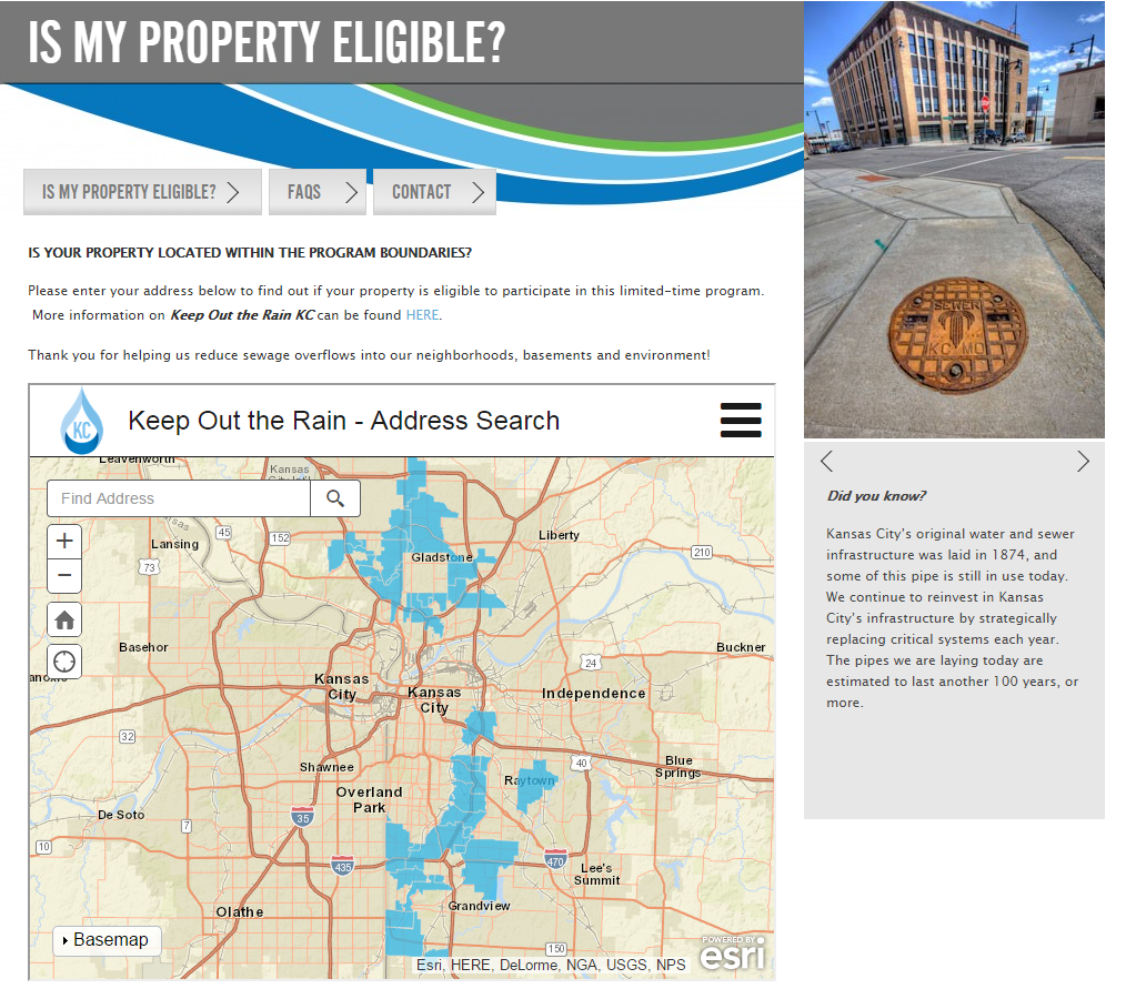
Along with geographically selecting addresses within the City to develop targeted mailings that notify property owners about the program and promote participation, ArcGIS has also been used to help the public determine if their property is eligible for the program by embedding an interactive map in the program website. The map allows property owners to search for their address and then indicates whether or not they are in the program area.
Efficient Data Collection and Data Sharing
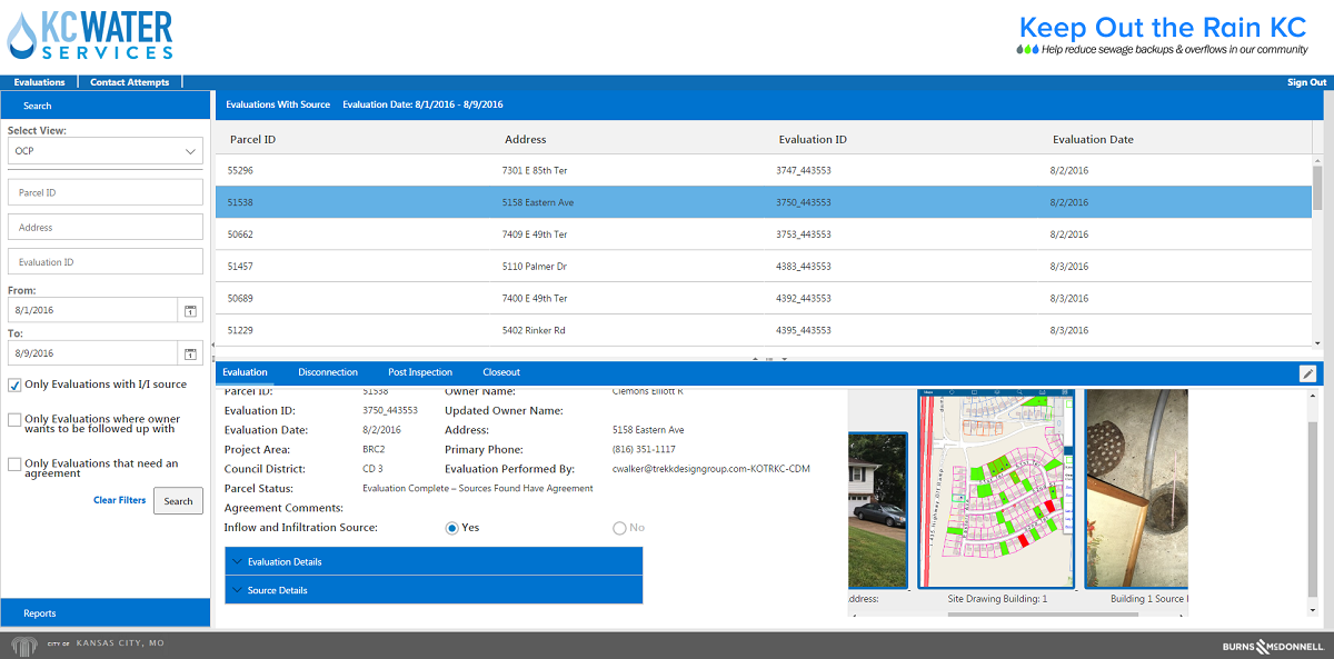
Property evaluation teams in the field are using the ArcGIS collector to assist in finding the properties they are assigned to evaluate. The system also provides the status of the assigned properties, displaying whether or not they have been contacted, had an evaluation performed and if inflow and infiltration sources were found on the property.
Additionally, the application provides the evaluators with a variety of reference information including:
- Property owner contact information
- Location of smoke testing observations, which may indicate that there is an inflow and infiltration source on the property
- The locations of where wastewater and stormwater infrastructure is located on a given property
The digital evaluation forms are directly integrated with the ArcGIS collector — eliminating the need for an evaluator to manually key in property information such as the parcel ID, owner name and address into the evaluation form. This integration increases the quality of the information being collected and makes the evaluation process more efficient.
Analyzing the Results
Having access to information in real time allows the project team to be agile in their approach to the project. Management is able to see what methods have been successful and capitalize on those methods while working to address any weaknesses.
To make content accessible to all program stakeholders, the program team has incorporated inspection information from ArcGIS into an online dashboard built on the Microsoft Cloud.
The dashboard allows easy access to evaluation information as well as on-demand reports that focus on the program’s key performance indicators.
The richness of data being collected in Keep Out the Rain allows the team to continually improve upon their approach to accomplishing project goals. To learn more about the Keep Out the Rain KC program and its ArcGIS implementation, leave a comment below or connect on LinkedIn.