 Success in today’s business landscape hinges on timely access to actionable information. Why use the Yellow Pages when “there is an app for that” accessible anywhere, anytime?
However, in order to access information electronically, the data must first be made available in a digital format. The challenge this presents is that most historical information exists only on paper and accessing it requires significant time. However, the thought of converting volumes of hard-copy documents into digital data is rightly perceived as a daunting undertaking.
Industries and firms that manage rights of way are especially prone to the challenges of managing historical data. For many, hard-copy engineering drawings and documents remain the data source of record. One reason for this is that most rights of way data are generated and developed over time in conjunction with the accumulation of multiple infrastructure build-out projects and commercial transactions.
Managing the Legacy
Dominion Virginia Power (DVP) is an investor owned utility that operates 6,400 miles of electric transmission lines housed by easements, fee-owned property and permits. As part of this process, DVP maintained thousands of original hardcopy plan and profile documents, some of which dated back to the 1930s. Not only was it time-consuming to track down the right document, but in some cases the data was completely outdated.
DVP’s Transmission Rights of Way Management Department recognized the inefficiencies of their outdated storage system, and DVP managers seized the opportunity to enhance their decision-making abilities by digitizing their rights of way data. The utility wanted to identify the best way to capture, categorize, manage, search and deploy the information quickly and accurately throughout the company and recognized that geographic information system (GIS) technology was likely the best solution.
The Staffing Challenge
Like most utilities and agencies, DVP did not have any in-house resources available for a major data conversion. A partner would be needed to help georeference the plans, orient them to their correct spatial location and digitize the information into a GIS platform so the staff could remain focused on their primary goal - supporting the daily operations of one of the nation’s largest producers and transporters of energy. The utility began looking for a company with transmission, right of way management and GIS knowledge to help close the staffing and technology gap.
The task turned out to be more difficult than expected. DVP found that many low-cost, traditional GIS firms existed, but they typically lacked in-depth industry knowledge and were unfamiliar with the complex workflow and business requirements used by the public utility sector. After exploring the options, DVP selected Burns & McDonnell, a full-service engineering, architecture, construction, environmental and consulting firm. The utility felt confident that Burn & McDonnell understood the utility business and its unique industry terminology. In addition to their extensive experience in program management, routing, design and construction oversight for transmission industry projects nationwide, the company’s GIS group is known for leveraging a robust suite of tools and technologies, and for using both customized and out-of-the-box solutions.
To determine the optimum path, DVP held upfront work sessions with the Burns & McDonnell GIS team to outline and discuss the utility’s business requirements in detail. After reviewing the existing database that contained more than 8,500 profiles, the team was able to gain insight into DVP’s long-term needs.
A Phased Project Approach
To ensure the utility could achieve their internal goals, DVP established an aggressive schedule, allocating between 12 and 15 months to complete the project. A phased approach, combined with a mix of staffing from four Burns & McDonnell offices and several trusted contractors, enabled the team to accommodate the schedule while keeping costs in line.
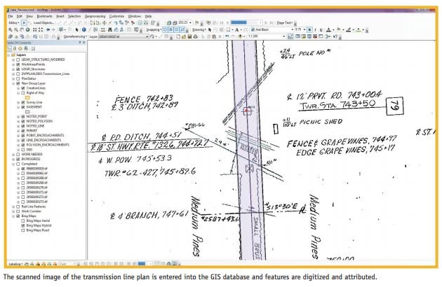
Phase I of the project called for the 8,500 plan and profile drawings to be georeferenced, the process of orienting the plans to their correct spatial location. Phase II focused on the digitization — drawing the features into GIS — of those drawings. The first phase provided a usable deliverable while building the foundation for executing Phase II. This not only streamlined the conversion effort, it also gave DVP access to all plan and profiles in a digital format. The DVP team was equipped with a useable product that made day-to-day operations more fluid and efficient, while the process of converting the plan and profile drawings into the final digital format remained ongoing.
Once Phase I was kicked off in April 2012, DVP provided the 8,500 plan and profile digital images so the team could process the imagery and begin the georeferencing process. This involved using transmission pole locations derived from DVP’s LiDAR data. A remote sensing technology, LiDAR measures distance by illuminating a target with a laser and analyzing the reflected light. By using accurate pole location information, the entire process of georeferencing was streamlined. After plans were split and adjusted to fit, the team returned more than 9,300 plans. Phase I was completed by October 2012.
In November 2012, Phase II commenced and is on track for completion in October 2013. It includes incorporating data about many transmission system features, such as rights of way, easements, permit features, noted features and encroachments. In many cases, the rights of way may have been expanded over the years, and the digital data must accurately display those expansions. The final product will allow DVP to easily access an easement within the GIS and pull up the real estate documents pertaining to that easement. The electronic format will not only aid the engineering design process for new transmission line projects, it will facilitate quicker rights analysis and provide valuable real estate data to other departments, such as forestry and construction.
The Factors for Success
Given the volumes of data collected over many decades, the project’s complexity was clear from the start. The project team understood that success would require efficient and timely communication, as well as the ability to manage complex data and the institutional knowledge to interpret the plan and profile drawings.
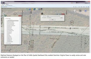
Processes and technologies were put into place that gave DVP real-time access to the status of the various phases, iterations and discussions per plan and profile. A project portal was used by team members to track each plan and profile, and a GIS web mapping application aided in the review process of the digitized work. Using the secure web portal, the team could access data anytime from anywhere.
The portal contains a plan and profile list with a record of each plan, along with data used to track georeference status, including review date, review status and name of each person who reviewed it. It also tracks the digitization status of each plan in much the same way. This has streamlined the process of relaying metrics during biweekly status calls and of measuring key performance indicators to track and report project progress.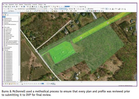

The GIS web mapping application was built on Esri’s ArcGIS platform and includes custom tools developed by Burns & McDonnell. The web mapping site displays which data has been completed and reviewed internally. DVP staff reviews the data through this portal as well. If a data issue is uncovered or comments need to be shared, reviewers create a redline version that is synced back to the master database and addressed by GIS professionals. Burns & McDonnell is then able to examine each redlined element and correct it, if necessary. Because the process of passing data back and forth on such a dynamic project has the potential to create issues, Burns & McDonnell is hosting the master data until the project is complete.
Focusing on the Future
Having the most accurate decision-making tools accessible has become a necessity in today’s fast-moving digital environment. Managing hard-copy data is a slow and inefficient way to oversee rights of way and its associated documentation. Converting thousands of files into a digitized format may seem overwhelming to consider, but with the right team in place, it can be done.
Digitizing rights of way data has proven to be a productive business strategy for DVP. Once this project is completed, DVP will have a fully searchable GIS database housing historical information on rights of way, property, permitted features, forestry and vegetation management and encroachments. We believe that using the latest technology can help the entire industry solve an age-old problem - keeping institutional knowledge relevant, useful and accessible.
Jacob Stevenson
Jacob is a GIS Specialist in the Burns & McDonnell Business & Technology Services Group. He served as the GIS lead on this Dominion Virginia Power project, overseeing data coordination, reviewing and maintaining the database and supervising a team of GIS professionals. With 12 years of experience working on large-scale GIS projects, Jacob has a Master’s of Science degree in Physical Sciences from Emporia State University, Emporia, KS.
Angelita Gardner-Kittrell
Angelita is the Supervisor of Dominion Virginia Power’s Transmission Rights of Way Management Department. Her experience includes nuclear licensing and safety, distribution load planning, circuit calculations and distribution and transmission right of way. She has a Bachelor’s of Science degree in Electrical Engineering from North Carolina Agricultural &Technical State University, Greensboro, NC.
This post originally appeared in the September/October issue of Right of Way magazine.